Home in Port Charlotte
High of 85*
Struck out yesterday. Worked the east side between the keys and the sand bar from Alligator Creek to Pirate Harbor. Had a pretty late start and was pleased to have made it behind the bar when the tide was already at .07 and falling. Many crab traps were already exposed.
After the turn of the tide I went out to the Jug Creek shoal and fished the grass flats. Saw a lot of activity from 2 to 245 but only hooked a puffer fish. Not sure what was chasing and feeding on the mullet but I tried 4 different lures and caught only grass. Tried top water, even though the sun was still high. Kept me out of the grass but no strikes.
Went up Jog Creek for the first time...nice channel, looks like it would hold lots of redfish but I could find any. Threw my spoon lure into the mangrove trees twice but was able to maneuver the little flats boat right to them and get it back. (That was the luck of the day).
Really the best news, besides the beautiful flat water and gorgeous weather, is that I filled my gas tank up yesterday morning before leaving home and found that my 3 previous fishing trips consumed a total of 9 gallons of fuel. My last boat would use 9 gallons of fuel in 3 hours, not three days. Yet one more reason I'm glad I made the switch.
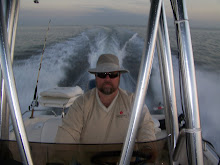
Here's a couple photos on the water, taken at 35 MPH, running home.
Click on each picture for full screen.

Click on picture too see full image

Below is a photo of where I fished. Look at the right side and see the Keys listed from Silcox Key down to Crow Key. You can see the long sand bar the runs the east wall of Charlotte Harbor. Most days, the sand bar is a foot or two under water. Today, that sand bar was a peninsula. At the bottom of the photo, you can see the Jug Creek shoal, directly beneath the letter k in Bokeelia Island. That's about 20 miles from my house. I've had good luck on sea trout there in the past but not today.
Click on picture to see full image

Below is a close up of the Shoal, in the upper left-center. Jug Creek can be seen as a narrow, winding channel, in the lower right, above Toms Bay.
Click on picture to see full image

1 comment:
I enjoy your blog, even though it makes the time drag here in Illinois LOL...
Dave
Post a Comment