Sunday, July 31, 2011

100% EMILY

Home in Port Charlotte
High of 96, humid days

Tropical Storm Don made landfall in SW Texas in the early morning hours of Saturday.  It never exceeded 60 MPH winds and there were no reports of flooding.  It had no affect on Florida or elsewhere in the Gulf.

Meanwhile, deep in the tropics of the Atlantic, a strong low pressure system has quickly organized for our next system.  Depicted in red in the photo above, the system has a 100% chance of becoming a named storm in the next 48 hours.  The next name on the list is Emily.  It is currently 3000 miles away from SW Florida, 675 miles east of the Lesser Antilles islands, moving west at 15 MPH.

The area in yellow is a disorganized wave of heavy showers that will become weakened as it crosses the Yucatan Peninsula near Belize and Guatamala.  It has a near 0% chance of becoming a tropical cyclone.

Below are the 8AM NWS radar images of the two systems. Click for full screen.


Closer to home, I spent Saturday our my grandson, Devin, building a floating dock on our canal.  While the other grand-twin, Dylan, decided to stay indoors and not join the labor crew, he was very sweet to show up with cold drinks for us during the job.  He also cleaned Mimi's kitchen while she was at work!

I will post pictures of the finished dock product.  My neighbor Ronnie, from NY, found a plan on the internet and modified it to make his own 5x12 floating dock.  I am using his plan to build mine, while he serves as a telephone consultant, live from New York.  It will replace my frequently popped inflatable dinghy as a maintenance barge and fishing lure recovery vessel.  Not as often as years past, but I still occassionally get lures hung up in trees along the canal.

Wednesday, July 27, 2011

DAWNING OF DON

Home in Port Charlotte
High of 93

I just returned from a quick 2 day trip to Miami and Homestead.  That tropical system I wrote about last Friday is still together.  It dropped heavy showers on Puerto Rico, the DR/Haiti and Cuba.  As it passed the mountains of Cuba it took a beating and weakened significantly but overnight it has reorganized with a well defined mass, as seen in the 70% photo below.  70% also represents the chance this becomes a named storm in the next 48 hours.  I knew I had a feeling about this wave.

The system is well west of Florida and poses no threat to us.  It is located about 125 miles east of Cancun, Mexico and moving west/northwest at about 15 MPH.  I don't know for sure, but I would imagine a hurricane hunter will fly through and take a reading on the center today.  The next name on the list is Don.
Click on photos for full screen.

8AM update:  The NWS has increased the liklihood of this becoming a named storm in the next 48 hours to 80%.  A hurricane hunter WILL investigate the system for a defined center of rotation later today.

Friday, July 22, 2011

FORECASTING THE FOURTH

Home in Port Charlotte
High of 90, severe thunderstorms all around but not on us

I arrived home for Baltimore/Washington DC at noon today (Friday).

By 5PM the temperature in SWFL had dropped to 76 degrees when much of the northeastern US was at 100 or above.  A severe thunderstorm started with 4" of rain in North Fort Myers and brought 60 MPH winds to Arcadia in nearby DeSoto County and even closer, the Punta Gorda airport recorded a 58 MPH gust.  We were braced to be hit hard but somehow it skirted around our house.  We had a light steady shower for about an hour, that produced about a quarter of an inch.

In the Tropics, Bret is now just a low pressure system and Cindy is still churning at a 60 MPH tropical storm but neither will affect landfall.  We are now tracking a new system, 200 miles south of the Lesser Antilles or the Windward Islands.  It is a broad area of low pressure that is well defined and growing.  There is currently only a 30% chance of it becoming a named storm in the next 48 hours but that was only 10% yesterday.

Based on the position and the conditions in the Caribbean, I'd guess this will be the fourth storm of the season.  The Virgin Islands and Puerto Rico can expect significant rainfall over the weekend as this system passes through.

Saturday I plan on doing some chores around the house and changing out the second of two baitwell pumps on my boat.  I will look at the weather for a possible fishing trip Sunday but right now I'm pretty exhausted from a week on the road.  I'm looking forward to a couple of nights in my own bed, before hitting the road again Monday.

Photos of the new tropical low are below. Click on pictures for full screen.

Thursday, July 21, 2011

TROPICS GETTING ACTIVE

Hampton Inn, Baltimore, MD
high of 104

A tropical wave of low pressure is forming east of the windward islands, deep in the eastern Atlantic.  It is too early to conclude if it is anything to be concerned about, just a 10% chance of becoming a named storm in the next 48 hours, but these things have to start out somewhere.  My friend Bill Dietrich is on his sailboat in Grenada.  I will follow his blog closely, that system approaches his position.

Tropical Storms Bret and Cindy are still playing around in the north Atlantic and have no chance of turning around toward the US.

My work week comes to an end Friday morning with a flight home from Baltimore to Tampa.  I'm looking forward to the cooler, dryer weather in South Florida.

Wednesday, July 20, 2011

CINDY JOINS BRET

Hampton Inn, Chantilly, VA
high of 96, heat index to 105
tomorrow, 100 & 111

A second tropical storm, Cindy, has formed in the Atlantic ahead of Bret.  Neither storm poses any threat of a US landfall.  Both will continue to blow northeast out into the cooler northern Atlantic water and fall apart.  What is real is the heat on the East coast.  My work in Washington, DC is making me long for the "drier climate" of Florida.

Tuesday, July 19, 2011

BRET NO THREAT

Hilton Garden Inn
Frederick, VA
high of 90 today

Tropical Storm Bret gained peak winds of 60 MPH but has weakened overnight to 50 MPH.  It is 200 miles northeast of the Abacos, Bahamas and 400 miles south of Cape Hatteras, NC.  Bret is no real threat to anyone, much less the Florida mainland.  It will continue to weaken over the next two days until falling back into a tropical depression on Thursday.

Sunday, July 17, 2011

TROPICAL DEPRESSION 2

Home in Port Charlotte
High of 90

I woke up this morning at 5AM to take the grand-twins, Devin & Dylan, beach fishing on the Gulf of Mexico.  We went to Stump Pass State Park, near Englewood.  It was a warm, humid morning with a partly cloudy sky and temperatures starting at 79, working up to 90.

The fishing was slow but Devin managed to land one rare lizard fish.  The boys spent some time swimming while I continued practicing my casting.  By 1030AM we headed for home, where Kathy had breakfast bagel sandwiches for brunch.  We were joined by Ron & Carol, our neighbors who are headed back to Long Island, NY tomorrow.  They will return in October.

The second tropical depression of the 2011 Atlantic Hurricane season has formed about 100 miles east of Melbourne, FL.  It is no threat to our area in Southwest Florida. Current winds are 35 MPH.  It is forecast to become the a Tropical Storm by tomorrow afternoon.  If it does, it will receive the name Bret.  Above is the "cone of uncertainty" showing the likely track it will take back out into the Atlantic and not make a US landfall.

The first named storm from this season was TS Arlene, which formed in the far western reaches of the Gulf of Mexico and the Bay of Campeche, last June 28.  Arlene was so far away from Florida, I didn't even blog about it.  She made landfall on June 30 in Mexico and the ensuing flooding took 22 lives.

Sunday, 8PM update:  the storm has strengthened and has become Tropical Storm Bret.

I'm flying out to Baltimore tomorrow evening for a week of working in Maryland and the DC Metro area.
I will continue to monitor the weather developments in the Atlantic while I'm on the road.

Thursday, July 14, 2011

TWENTY YEARS FROM NOW

Home in Port Charlotte
Highs around 88, scattered showers

I took my 11 year old twin grandsons, Dylan & Devin, along with their Dad, Curt, all who are visiting from Arizona out fishing in the Boca Grande Pass (BGP).

It was a nice 20 mile run in light seas. We went through one passing shower but quickly out ran it. Once at the BGP we dropped live shrimp in and Devin was immediately hooked up. To all of our delight, he pulled up a 24" Bonnethead Shark. When a soon to be 6th grader from Phoenix goes back to school with pictures of the shark he caught, that's a great "how I spent my summer vacation" story. Throughout the day, tarpon were rolling all around us and we saw two incidents of tarpon being ambused by huge sharks at the surface.

Dylan set his own mark as a salt water legend by landing the biggest Gag Grouper ever caught on my boat, to date.  Even though it was 2" short of keeper size, gags are out of season this summer so we'd have had to release him anyway.  We took photos, below, and released him alive and well.  I take great pride in showing the boys the importance of reviving their fish for a successful release. We have a tradition of saying, "Catch ya later!" as the fish swim back down to the bottom.

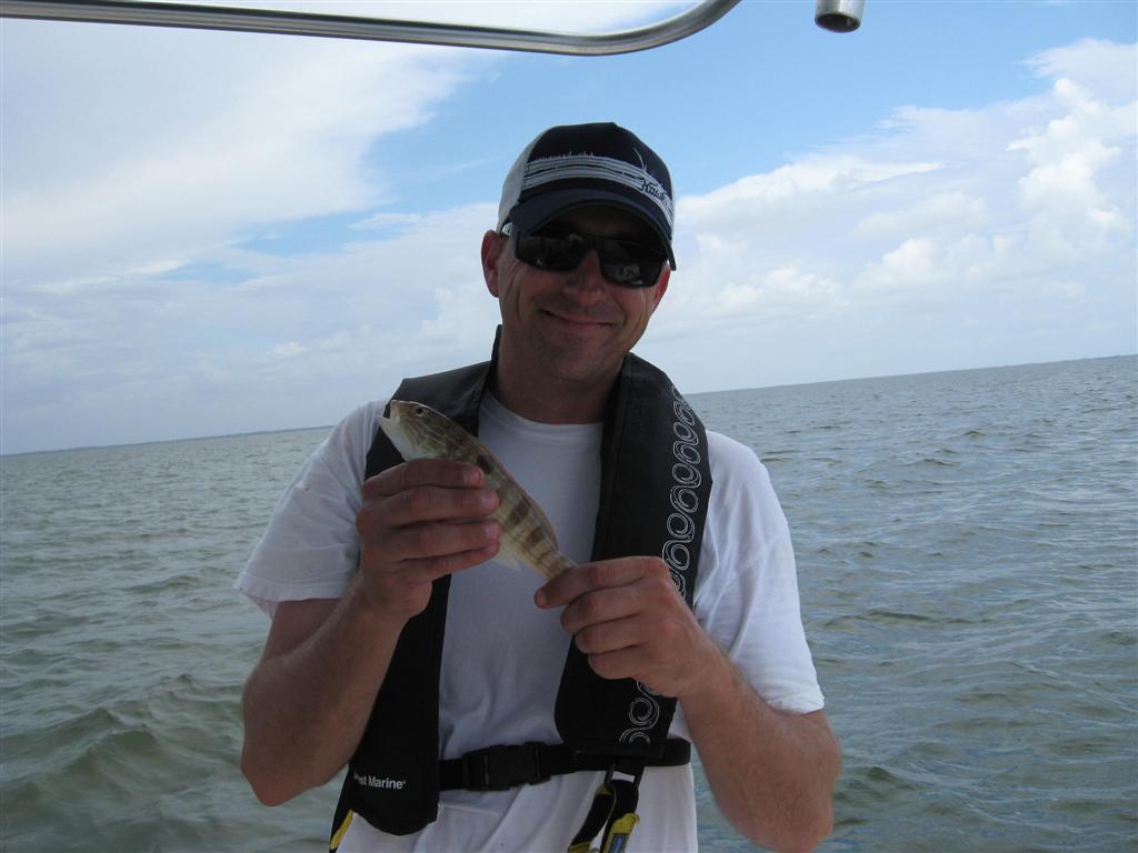
I acted as both Captain and crew, not fishing but just working for all these guys, to ensure they had the best time possible. We caught and released many red and gag grouper, the biggest of which were 18 and 19 inches long, both caught by the twins.  Curt's first hook up was a little white grunt, which he allowed me to photograph for comic relief (below).  He followed that up with several red and gag grouper and a cat fish.
Curt had an incredible hookup with a 30 minute fight that ended in disappointment.
The afternoon winds picked up the seas and by 2PM, Boca Grande was showing white caps. We boated over to Pelican Bay, off Cayo Costa, to get on the lee side of the island and have lunch anchored down in 24" of calm water with a light breeze, about 100 yards from a sandy beach. I took a rare swim in the Bay but no one else wanted to (perhaps those sharks were still fresh in their minds).

By 3PM we decided to try for one more hookup each and went back into the pass. Once we got into 60' of water, the twins decided they'd had enough and just wanted to watch. Curt and I baited up live pinfish on 30lb test and dropped them over. Very quickly we were both hooked up but we realized these were not grouper or small sharks. My line zipped out at the speed of light and quickly went limp. Bait gone.

Curt was in even more trouble. His 300 yards of braided line was getting spooled. I jumped into the helm and fired up the boat. We chased after the line as Curt told me he was down to the last few strands of mono at the bottom of the Penn spinning reel. I've never had this happen on my boat. Curt said he could see the loop at the end of the line.  I was prepared to see it go.  We used the boat to recover the line back to where we could see the green braid line on the reel and Curt did a good job directing me from his fighting chair, telling me when to go neutral and when to go forward. That green braid was really hard for me to see from the helm.

The fish would be under our boat in one second and then charge out ahead of us the next. I'm pretty sure it was a Tarpon from the way I saw the line acting. He may have also been being pursued by sharks because he was clearly in a desperation panic mode. We ended up getting back about half of our line before the line was broken and limp. The fight lasted about 15 minutes and Curt was pretty impressed with the physical battle. He'd never known fishing could be like this.

In choppy 3' seas we headed for home. The twins enjoyed the occassional "banger" as we tried to keep the boat near 20 knots. We went airborn a couple of times.  We never did get anymore rain on us but saw it all around us. As we got behind the lee shore in Alligator Bay I was able to get the boat up to 36 knots, even with full bait wells, 4 guys and all our gear aboard. Not bad.  I've already put more hours on this boat in 4 months than I did on the last one in 3 years.

By 5:30 we were back on my lift, exhausted but full of new memories of Messing About in South Florida. I can't help but believe that 20 years from now, the twins will be sitting together, having a beer, watching their own kids play or fish and one will say..."Remember those summers in Florida on Pappy's boat?" "Remember when you caught that shark?"


(Click on pictures for full screen image)

Devin's Bonnethead shark. FINS UP!

Dylan set a grouper boat record with this 20" Gag

Dylan did a great job bringing this Gag up from 50' below


Curt shows his humble side by posing with his white grunt. 
He followed this up with several more blog worthy catches.


Sunday, July 10, 2011

MAN OVERBOARD!

Las Vegas, NV for work meetings

Yesterday I took my brother in law, Billy, and his wife Joan out for a pleasure cruise.

We launched at 830AM and we pleasantly surprised to finddead calm flat water from the upper harbor to half way to the Intercoastal Waterway at Boca Grande Pass. I tried to anchor down on the north shore of Gasparilla Pass but my anchor pin wouldn't hold in the loose sand below. After a few tries and failures, the current was like a swift water rapids, we found ourselves in trouble...getting bounced around on the 6-18" floor. I was forced to raise the outboard to protect the shaft and I tried to use the trolling motor, but again, the current kept slamming us into the sandy shoal. With the tide falling, the only way out was to jump out and manually tow the boat to deeper water.  The current was soooo strong, we really struggled to kep our footing.  We were both wearing vests and the water was shallow, so there was never any real danger to us...just the boat.

I put Joan at the helm and had her calling out depths to us.  I really just needed a consistent 2' to feel good about firing up the outboard but Joan kept saying the depths were 0.6, then 1.2, then 0.9.  It never dawned on me that I was in chest deep water when she was telling me we were in 1 foot.  Finally I decided the depth meter must be damaged from running aground so I told Joan to drop the motor and fire it up.  She did and was able to drag Billy and I to deeper water.  I quickly ordered all aboard via the swim deck ladder on the transom.  Billy went first, then me.  I hollered for him to move so I could take the helm.  He tried to move so fast, he fell overboard!  HAHAHAHAHA....I told him to quit screwing around, we got to go!

Not really but he climbed back in so fast you'd have thought the water was on fire.  It actually felt wonderful I really wish we could have stayed swimming for a bit.   We got ourselves to 25' of water in 30 seconds and Joan had to go pee.  I pointed at the depth meter and saw it was working fine and she said, "Oh that's the depth?   I was looking at this," as she pointed to our speed: 2.1 knots.  HAHAHAHAHHA....that explains alot.

Thankfully, my bro-in-law and his wife stayed calm throughout the ordeal and we were no worse for wear.  We had lunch on the water at the Gasparilla Grill and it was very good. I inspected all systems and found no damage.

We then cruised the ICW back to BGP and into the Gulf channel just so my guests could say they boated in the Gulf. The winds on the day were less than predicted, which was nice. We had a light chop on the way home and landed at my port at 3PM.

The good news was the water was a beautifully comfortable temperature. The bad news was we didn't get to relax in it. We ran 61 miles on the day and used about 20 gallons of fuel.

We also spent much of the evening laughing about the entire ordeal.

Thursday, July 7, 2011

HERE COMES THE RAIN


On the road, Homestead, FL
Heavy rain predicted

A tropical wave of low pressure is going to pass over South and Southwest Florida today and tomorrow.  Significantly heavy rain, with a chance of flooding in some low lying areas is predicted.  It takes a lot to flood here because the sandy soils drain so quickly.

This could be the most rain we've seen here since TS Faye in 2008.  As you can see above, the system covers a wide area, from the Caribbean, across Cuba, all the way in the Gulf of Mexico.

The system is expected to depart our area early Saturday.  There is a very low chance, 10%, of this system turning into a named storm.

Tuesday, July 5, 2011

BRIEF UPDATE

On the road, Boynton Beach, FL
High of 91, partly cloudy

I've been quite busy with work lately, from Boston to Chicago to Detroit and finally home for the 4th.
I left at 4AM this morning and will be spending the week working on FL's Atlantic coast.
I, like most, was very disappointed to learn of the verdict in the Anthony trial.  I spent considerable time on my vacation watching the trial and feel like I had a good grasp on the facts.  Unbelievable turn of events.

I haven't been on boat for 2 weeks but plan on going out Saturday.  We have my wife's side of the family coming to visit and will have our grand-twins for 3 weeks.

Between all of that, I have a Sunday flight to Las Vegas for a work meeting.  The last two times we had meetings in Vegas, I'm happy to report I didn't spend a dime.  This time will be no different.