
This is our tricky bridge. We have to be close to low tide or we can't clear under it.

This catamaran is owned by a friend of our next door neighbors. He keeps it moored at the Charlotte County Beach Complex.

Leg 1 of our journey was 22 miles out to Boca Pass. This is where Charlotte Harbor meets the Gulf Of Mexico.

As we approach, we notice dozens of anglers anchored down in the pass.

Click on the above to see how many boats were there.

Hard to take photos in 3 foot seas.

South of Boca Pass is the Island of Cayo Costa. This is where we anchored down for lunch.

This Gibson reminded us of Nolan & Nancy's Holiday Mansion.
While anchored down, we called Nolan to tell him we were thinking of him.

Others anchored down near us.

Still more anchored down at Cayo Costa.

My bride shows off her new ultra comfy life vest.
We have committed to wearing these at all times when underway.

These fools loaded 5 into a dingy made for 2.

Usepa Island is for the super rich. There are no bridges to the isle, only boats.

Usepa Island homes.

Usepa Island homes.

More Usepa riches.

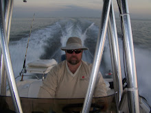
At the helm.

She leaves a nice, pretty wake.

Click to enlarge and see the water crashing about.

A dream come true. After nine months of dreaming, we docked our boat at Burnt Store Marina for lunch.

As we head back out to open water, we had no idea what waited on the other side.
The 9AM departure was perfectly timed to clear the low bridge. The float plan was well thought out and geographically accurate. The noon break at Cayo Costa reminded us of why we moved here. We saw so many dolphins, we lost track. Unfortunately we were unable to photograph any of them. As we approached Burnt Store, it was a moment I had dreamed of: "Burnt Store Marina, Burnt Store Marina, this is the motor vessel Messin' About." The harbor master gave us permission to dock on the seawall right in front of Porta Bellos at Lattitude. We had a nice late lunch and set out for the final leg of our journey, right on time. The above video was shot as we exited the marina back to the harbor.
When we got into the open water, the winds had picked up substantially. The 2-3 foot seas had been replaced with occasional 5 footers crashing over our bow. The wind was out of the west at about 20 knots but we had to cross the winds, heading north for 20 miles. Sorry for not capturing video of that excitement but we were busy trying to hold on to the boat. There were some tense moments but the experience of handling the boat in the conditions was priceless. I felt confidently in control the entire time. Kathy would have NEVER let us launch in weather like this at Lake Pleasant but the fact was, we were here and the only way to get home was to cross these rough seas. We averaged 20kph across and got completely drenched from head to toe by the salty sea. Kathy was on the wind side and took the brunt of the breakers. She may have suffered some nerve damage but was supportive of my efforts to get us home safe, which I did.
The bridge re-entry was timed perfectly and we docked at the home port at 6:00 PM, just as planned. The trip results were as follows:
73 miles traveled; 7 hours and 33 minutes underway; 34 minutes at idle; average speed 24; top speed 31; fuel usage, approximately 20 gallons. Time flushing and cleaning the boat - 2 hours.
No comments:
Post a Comment