


Either one would make a great title to this chapter.
As you know, Friday was the day we schedule to bring home our new 26' SeaMaster. And we did. On the 2 hour ride home, I was thinking of what I might call this chapter. I thought of Ride, Captain, Ride. After all, to me this was a bit of a mystery ship. Or I could have called this chapter The Magical Mystery Tour, because I had previously never ventured into these coastal waters and here I was; underway in a a strange boat, on the intracoastal waterway of the Gulf of Mexico, all by myself. Some might have penned this chapter What Was He Thinking?
The Gulf intracoastal waterway was developed by Army Engineers in the 1800s, as a way of linking the Atlantic Ocean with the Gulf of Mexico without the long and dangerous trip all the way around the southern tip of the Florida Peninsula. The first stages of construction were interrupted by the War of 1812. (for a good history lesson, read "History of the Gulf Intracoastal Waterway" by Lynn Alperin, published in 1983. It's free online) Nowadays, the ICW is used by recreational boaters and commercial alike, as a way to traverse the Gulf and Atlantic coasts, without being in the high seas of the oceans. Think of it as a river that runs parallel to the ocean. The Army's role was to dredge (dig) out a safe depth in water that was already there. The government also marked the channel with a series of navigational signage to aid boaters on their way. The law called for the channel to be maintained at a minimum depth of 20' but lack of funding over the course of time has made the reality of the depth be an average of 12' or so.
12:15 PM Hour meter 322.2
My journey began in St. James City, on the south end of Pine Island. The ICW was very calm this day and my confidence was high. The navigation aids in the water, coupled with my Garmin GPS unit, made for an easy trek the first 24 miles to Charlotte Harbor. I think that I will never forget the first big spray of sea water to strike my face and fill my lips with the taste of sea salt. It was a defining moment for this stage in our life. Kathy had driven home from the island and was anxiously awaiting my arrival, camera in hand.
When I made the turn from the ICW into Charlotte Harbor, there were 15KPH winds kicking up her seas. White caps were appearing and the boat began some gentle rising and falling. I had seen conditions like this at Lake Pleasant, I just never piloted the boat in them. I thought to myself that I had mentally prepared for this moment for nearly two years. I had no fears as I plotted a course toward Punta Gorda.
I couldn't see landfall, for some low lying clouds 16 miles away. I realized that all those hours I spent studying Google Earth were paying off because even though I have never really been here, at this spot, on this water. I knew exactly where I was. And I was right where I wanted to be.
I found my way to the entrance to our system of residential canals. I knew I would have three bridges to pass under. It was about 2:30PM. I thought I had planned this out well enough to beat the high tide, set for 5:45. The second bridge was another piece of cake, as I cruised right under it. Less than 1 mile to home. One more bridge to pass.
Wasn't there a book called, "A Bridge Too Far"?
First understand that I had called the county and asked them the clearances. They said they don't publish bridge clearances because of the liability related to the changing tides. Their official stance is check for yourself. I had used my fishing reel with the depth meter to check the Pellam Bridge, which I knew to be the lowest in my area. On the day I checked it there was a good foot to spare, to get my hardtop underneath it, if it wasn't at high tide.
As I rounded the corner toward the Pellam, I knew as soon as I saw it. I can't make it. It was so noticeably lower than the Midway and Countryman bridges, it wasn't even funny. I approached at a snails pace. About 20 feet away, I shifted to neutral and left the helm. Our boat is called a Walkaround model, with good reason. I can get from helm to bow in 5 seconds. I stood on the pulpit and caught the bridge with my hands, stopping the 4800 pound vessel. I was about 10 inches too tall and the tide was still rising. It was about 3:00PM. Thank goodness this boat has a good Garmin unit. I backed off and checked the tides on the Garmin. I was currently at 2.0 feet above mean tide. High tide was predicted to be 2.3 above. Low tide was going to be -.05 below mean tide.
I called my bride and gave her the news. She asked how long I was going to have to wait. About 5 hours, by my estimate. I was going to have rising water for another hour and forty five minutes and then would have to wait for it to slack. Kathy punched my coordinates into her own Garmin unit and drove over to see me. She was there in 2 minutes. That's how close to home I was. (insert Maxwell Smart line here)
I would waste a lot of fuel if I remained under power. I turned around and starting looking for a safe port to tie up for a few hours. The good news was, 1 in 3 homes here have docks in their backyards. The better news was only about 1 in 5 of those have boats on them. I wasn't going to just squat on someones property. I had to find a person to ask and fortunately I did. I tied up on a nice dock owned by a 90 year old man and his young Polish immigrant bride. (She was probably about 70). My own bride plotted a course to their house and brought me some much needed water to drink. I spent an hour or so talking to the old man and found him to be very interesting and mentally strong. He has been on the canal for 25 years but he gave up his boat after the first 5. The maintenance got to be too much for him. He told me his story of Hurricane Charley in 2004, how three of his royal palms snapped at the base and ended up blocking the canal. He said the aftermath of the storm made the canals unusable for nearly a year while the county tried to cleanup. Roads were the priority and ours was one of the last canals to be cleaned. I have heard several people here tell me their Charley experiences and although I find the stories fascinating, I have zero interest in seeing a category 5 first hand. I am surprised how many people throughout Florida wait it out in their own homes. They say the roads are just too congested to get anywhere and the risk of staying home outweighs the risk of being stuck on the roadside somewhere.
At 8PM I untied from the polish dock and headed back to the Pellam. The water level was showing 1.8 feet above mean tide. That's only 2 tenths of a foot lower than where it was 5 hours ago. I pulled the same drill, approaching at a snails pace, shift to neutral, abandon the helm and take a position in the bow pulpit. The hardtop would clear, but the Garmin antenna wouldn't. If I'd had my tools I could have removed it and been home. No such luck. I had to continue to idle the motor because if a wind gust came up, I might not have time to fire her up before making a move. I stood up front and held onto the bridge. At about 8:30PM it started getting seriously dark. I better turn on my navigation lights. Guess what? They don't work. I called the sellers and was really upset when Carolyn told me that Larry was asleep but she thinks Woody said "they're burned out." What the F***? They let me take delivery without telling me I have no navigation lights? I know they are basically really nice people, who are in a sad spot in life with Larry dying, but that's just wrong. Oh well, I needed God's help now so I wasn't about to start damning people for doing me wrong.
Man, this water recedes alot slower than it rises. 8:45 PM and it's really really dark. There is some ambient light from some people's homes and a few with lights on their docks, but it's freaking dark outside. Remember, I've never been in the water on this canal.
My good Catholic upbringing suddenly came back and I was a reborn, God fearing Christian. No joking. I started praying out loud. I was scared. I had to get this boat under the bridge and get home. There was no turning back to tie up somewhere now. It was too dark and I had no nav lights, no spotlight and no flashlight. There was a flare system, but come on. I'm minutes from home.
1.7 feet above mean tide. Still too high. 9:00 PM, darker and darker by the minute.
1.6 feet is still too high. I'm praying Hail Marys and Our Fathers, out loud. This is serious stuff. My worry has shifted from when I get home to IF I GET HOME. If I run into someones dock or boat, I am so screwed.
1.5 feet at 9:20. I think I can make it. I literally used my arms to push on the underside of the bridge and force the boat another inch or two into the water, as I walked her underneath. MADE IT! Thank the good Lord.
With Kathy on the speaker phone, standing by on our dock with a mag light, I gently throttled up. My depth finder was going between 3 and 5 feet. I needed to stay in the center of the canal but it was hard to see where that was. All of the vacant lots in the neighborhood have decades of pepper tree jungles growing into the water. My Garmin didn't have a record of this canal, so I turned it off to keep the glare out of my eyes. I knew from Google Earth I had one last right turn to make but I had to find the intersection. Here it is.
I made my right turn and told Kathy to start flashing the light toward me to give me an idea of where home was. Nothing. "Are you flashing it?" "Yes, Bill I am waving it downstream like crazy." I can't see a thing. Wait, this doesn't seem right. Our canal has no houses across from ours. This canal has boats, docks and homes on both sides. I made a wrong turn. Holy cow, I'm going to have to turn this single engine boat around in the dark. Kathy was like an angel of calm. She kept telling me I would be okay, that I knew what I was doing and that I would make it. She was so great. And she was right. In pitch black, with only the light of a quarter moon, I made the u-turn. I got back to where I had been and went deeper into the neighborhood. No one has lights on down here. In the dark I could see cars headlights, through the brush, driving laterally ahead of me and I knew I was close. There's a street west, across our canal. I found another right hand turn and made it. I could see Kathy's light. OH MAN, I'M GONNA MAKE IT!
We got her tied up and Kathy handed me a Corona she had waiting for me.
As you know, Friday was the day we schedule to bring home our new 26' SeaMaster. And we did. On the 2 hour ride home, I was thinking of what I might call this chapter. I thought of Ride, Captain, Ride. After all, to me this was a bit of a mystery ship. Or I could have called this chapter The Magical Mystery Tour, because I had previously never ventured into these coastal waters and here I was; underway in a a strange boat, on the intracoastal waterway of the Gulf of Mexico, all by myself. Some might have penned this chapter What Was He Thinking?
The Gulf intracoastal waterway was developed by Army Engineers in the 1800s, as a way of linking the Atlantic Ocean with the Gulf of Mexico without the long and dangerous trip all the way around the southern tip of the Florida Peninsula. The first stages of construction were interrupted by the War of 1812. (for a good history lesson, read "History of the Gulf Intracoastal Waterway" by Lynn Alperin, published in 1983. It's free online) Nowadays, the ICW is used by recreational boaters and commercial alike, as a way to traverse the Gulf and Atlantic coasts, without being in the high seas of the oceans. Think of it as a river that runs parallel to the ocean. The Army's role was to dredge (dig) out a safe depth in water that was already there. The government also marked the channel with a series of navigational signage to aid boaters on their way. The law called for the channel to be maintained at a minimum depth of 20' but lack of funding over the course of time has made the reality of the depth be an average of 12' or so.
12:15 PM Hour meter 322.2
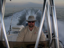
My journey began in St. James City, on the south end of Pine Island. The ICW was very calm this day and my confidence was high. The navigation aids in the water, coupled with my Garmin GPS unit, made for an easy trek the first 24 miles to Charlotte Harbor. I think that I will never forget the first big spray of sea water to strike my face and fill my lips with the taste of sea salt. It was a defining moment for this stage in our life. Kathy had driven home from the island and was anxiously awaiting my arrival, camera in hand.
When I made the turn from the ICW into Charlotte Harbor, there were 15KPH winds kicking up her seas. White caps were appearing and the boat began some gentle rising and falling. I had seen conditions like this at Lake Pleasant, I just never piloted the boat in them. I thought to myself that I had mentally prepared for this moment for nearly two years. I had no fears as I plotted a course toward Punta Gorda.
I couldn't see landfall, for some low lying clouds 16 miles away. I realized that all those hours I spent studying Google Earth were paying off because even though I have never really been here, at this spot, on this water. I knew exactly where I was. And I was right where I wanted to be.
I found my way to the entrance to our system of residential canals. I knew I would have three bridges to pass under. It was about 2:30PM. I thought I had planned this out well enough to beat the high tide, set for 5:45. The second bridge was another piece of cake, as I cruised right under it. Less than 1 mile to home. One more bridge to pass.
Wasn't there a book called, "A Bridge Too Far"?
First understand that I had called the county and asked them the clearances. They said they don't publish bridge clearances because of the liability related to the changing tides. Their official stance is check for yourself. I had used my fishing reel with the depth meter to check the Pellam Bridge, which I knew to be the lowest in my area. On the day I checked it there was a good foot to spare, to get my hardtop underneath it, if it wasn't at high tide.
As I rounded the corner toward the Pellam, I knew as soon as I saw it. I can't make it. It was so noticeably lower than the Midway and Countryman bridges, it wasn't even funny. I approached at a snails pace. About 20 feet away, I shifted to neutral and left the helm. Our boat is called a Walkaround model, with good reason. I can get from helm to bow in 5 seconds. I stood on the pulpit and caught the bridge with my hands, stopping the 4800 pound vessel. I was about 10 inches too tall and the tide was still rising. It was about 3:00PM. Thank goodness this boat has a good Garmin unit. I backed off and checked the tides on the Garmin. I was currently at 2.0 feet above mean tide. High tide was predicted to be 2.3 above. Low tide was going to be -.05 below mean tide.
I called my bride and gave her the news. She asked how long I was going to have to wait. About 5 hours, by my estimate. I was going to have rising water for another hour and forty five minutes and then would have to wait for it to slack. Kathy punched my coordinates into her own Garmin unit and drove over to see me. She was there in 2 minutes. That's how close to home I was. (insert Maxwell Smart line here)
I would waste a lot of fuel if I remained under power. I turned around and starting looking for a safe port to tie up for a few hours. The good news was, 1 in 3 homes here have docks in their backyards. The better news was only about 1 in 5 of those have boats on them. I wasn't going to just squat on someones property. I had to find a person to ask and fortunately I did. I tied up on a nice dock owned by a 90 year old man and his young Polish immigrant bride. (She was probably about 70). My own bride plotted a course to their house and brought me some much needed water to drink. I spent an hour or so talking to the old man and found him to be very interesting and mentally strong. He has been on the canal for 25 years but he gave up his boat after the first 5. The maintenance got to be too much for him. He told me his story of Hurricane Charley in 2004, how three of his royal palms snapped at the base and ended up blocking the canal. He said the aftermath of the storm made the canals unusable for nearly a year while the county tried to cleanup. Roads were the priority and ours was one of the last canals to be cleaned. I have heard several people here tell me their Charley experiences and although I find the stories fascinating, I have zero interest in seeing a category 5 first hand. I am surprised how many people throughout Florida wait it out in their own homes. They say the roads are just too congested to get anywhere and the risk of staying home outweighs the risk of being stuck on the roadside somewhere.
At 8PM I untied from the polish dock and headed back to the Pellam. The water level was showing 1.8 feet above mean tide. That's only 2 tenths of a foot lower than where it was 5 hours ago. I pulled the same drill, approaching at a snails pace, shift to neutral, abandon the helm and take a position in the bow pulpit. The hardtop would clear, but the Garmin antenna wouldn't. If I'd had my tools I could have removed it and been home. No such luck. I had to continue to idle the motor because if a wind gust came up, I might not have time to fire her up before making a move. I stood up front and held onto the bridge. At about 8:30PM it started getting seriously dark. I better turn on my navigation lights. Guess what? They don't work. I called the sellers and was really upset when Carolyn told me that Larry was asleep but she thinks Woody said "they're burned out." What the F***? They let me take delivery without telling me I have no navigation lights? I know they are basically really nice people, who are in a sad spot in life with Larry dying, but that's just wrong. Oh well, I needed God's help now so I wasn't about to start damning people for doing me wrong.
Man, this water recedes alot slower than it rises. 8:45 PM and it's really really dark. There is some ambient light from some people's homes and a few with lights on their docks, but it's freaking dark outside. Remember, I've never been in the water on this canal.
My good Catholic upbringing suddenly came back and I was a reborn, God fearing Christian. No joking. I started praying out loud. I was scared. I had to get this boat under the bridge and get home. There was no turning back to tie up somewhere now. It was too dark and I had no nav lights, no spotlight and no flashlight. There was a flare system, but come on. I'm minutes from home.
1.7 feet above mean tide. Still too high. 9:00 PM, darker and darker by the minute.
1.6 feet is still too high. I'm praying Hail Marys and Our Fathers, out loud. This is serious stuff. My worry has shifted from when I get home to IF I GET HOME. If I run into someones dock or boat, I am so screwed.
1.5 feet at 9:20. I think I can make it. I literally used my arms to push on the underside of the bridge and force the boat another inch or two into the water, as I walked her underneath. MADE IT! Thank the good Lord.
With Kathy on the speaker phone, standing by on our dock with a mag light, I gently throttled up. My depth finder was going between 3 and 5 feet. I needed to stay in the center of the canal but it was hard to see where that was. All of the vacant lots in the neighborhood have decades of pepper tree jungles growing into the water. My Garmin didn't have a record of this canal, so I turned it off to keep the glare out of my eyes. I knew from Google Earth I had one last right turn to make but I had to find the intersection. Here it is.
I made my right turn and told Kathy to start flashing the light toward me to give me an idea of where home was. Nothing. "Are you flashing it?" "Yes, Bill I am waving it downstream like crazy." I can't see a thing. Wait, this doesn't seem right. Our canal has no houses across from ours. This canal has boats, docks and homes on both sides. I made a wrong turn. Holy cow, I'm going to have to turn this single engine boat around in the dark. Kathy was like an angel of calm. She kept telling me I would be okay, that I knew what I was doing and that I would make it. She was so great. And she was right. In pitch black, with only the light of a quarter moon, I made the u-turn. I got back to where I had been and went deeper into the neighborhood. No one has lights on down here. In the dark I could see cars headlights, through the brush, driving laterally ahead of me and I knew I was close. There's a street west, across our canal. I found another right hand turn and made it. I could see Kathy's light. OH MAN, I'M GONNA MAKE IT!
We got her tied up and Kathy handed me a Corona she had waiting for me.
The journey begins.
Hour meter 327.7
2 comments:
I loved this post and this blog.
Have a nice weekend.
See, what would you do without Kathy...she knew exactly what you needed once you got home. LOL That's hilarious.
Post a Comment